Most visitors to New River Gorge National Park miss the rich natural and cultural layers that make this place truly extraordinary and worth preserving. To understand its full story, we have to look beyond history, into prehistory. In this post, we offer a broad overview of the Gorge’s fascinating past with a suggested hike at the end of each section so you can walk through history yourself.

The New River
The centerpiece of this magical place is the New River. But don’t let its name fool you, it’s one of the oldest rivers in the world. Many scientists believe the New River is the one remaining part of the ancient Teays River which existed before the Appalachian Mountains were even formed. According to the NPS, “It is possible that the New River is older than ANY mountain range in the entire world.”
You see, most rivers flow at the base of mountains. They are an accumulation of the water – the streams – that run from the peaks. But scientists know that the New River once flowed at the TOP of the Appalachian Mountains. This route implies that the New River rose WITH the mountains millions of years ago. It has been slowly but surely eroding a channel through the mountains ever since.
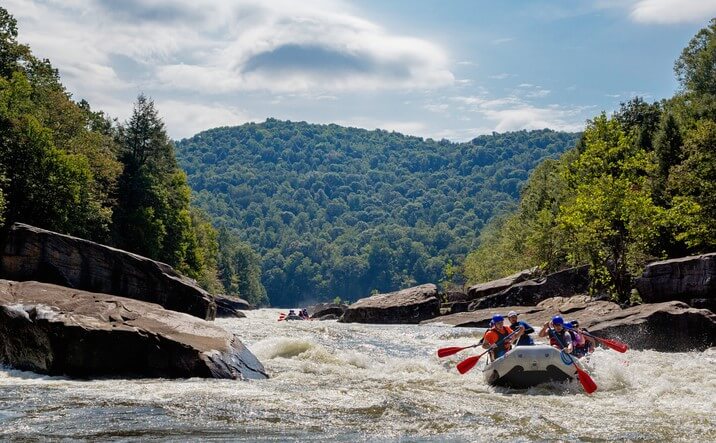
When you’re deep in the Gorge, it’s easy to experience the energy still coming from the New River. You can see the whitewater, hear the roar of the rapids, and feel the spray of rushing water.
Our hiking recommendation for best experiencing the New River is the Southside Trail. This 7-mile (one-way) easy trail offers up-close views of the river, Surprise Rapids, and access to Red Ash Island.
Reference and Additional Resource
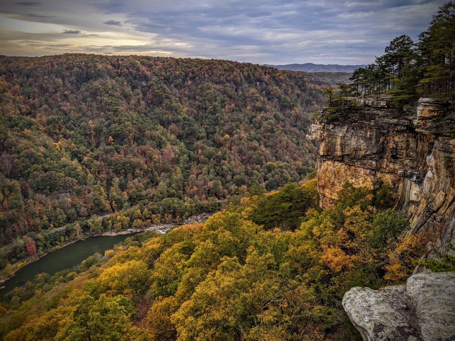
The Appalachian Mountains
Did you know that the Appalachian Mountains are older than the Rockies, the Himalayas, and the Alps? Hundreds of millions of years ago, tectonic plates all over the world started colliding, and the supercontinent of Pangaea was created. The series of collisions and resulting friction pushed the land up creating the Appalachian Mountains.
Much later, Pangaea began to pull apart. What is now North America separated from what is now Europe and Africa and the mountain building stopped. Erosion slowly wore away the extremely tall peaks of the ancient Appalachian Mountains. Sediment filled the valleys and an almost flat plane remained.
Then, about 20-60 million years ago, the whole region got uplifted again due to more shifting of the tectonic plates. This uplift – the creation of the Appalachian Plateau – rejuvenated the rivers and streams. The water started cutting through the rock while, at the same time, the rock was rising.
Cruising around Fayetteville, it’s easy to forget that you are sitting on top of an ancient mountain range. But take a hike in the New River Gorge and it becomes evident: You are IN the mountains, quite literally. Above and below, you can see and feel rock that is millions of years old.
Our hiking recommendation for best experiencing the Appalachian Mountains is the Grandview Area Trails. This area of New River Gorge National Parks has several gorgeous overlooks, a visitors center, and six trails. Grandview Rim Trail and Castle Rock Trail are best for viewing the mountains.
Reference and Additional Resource
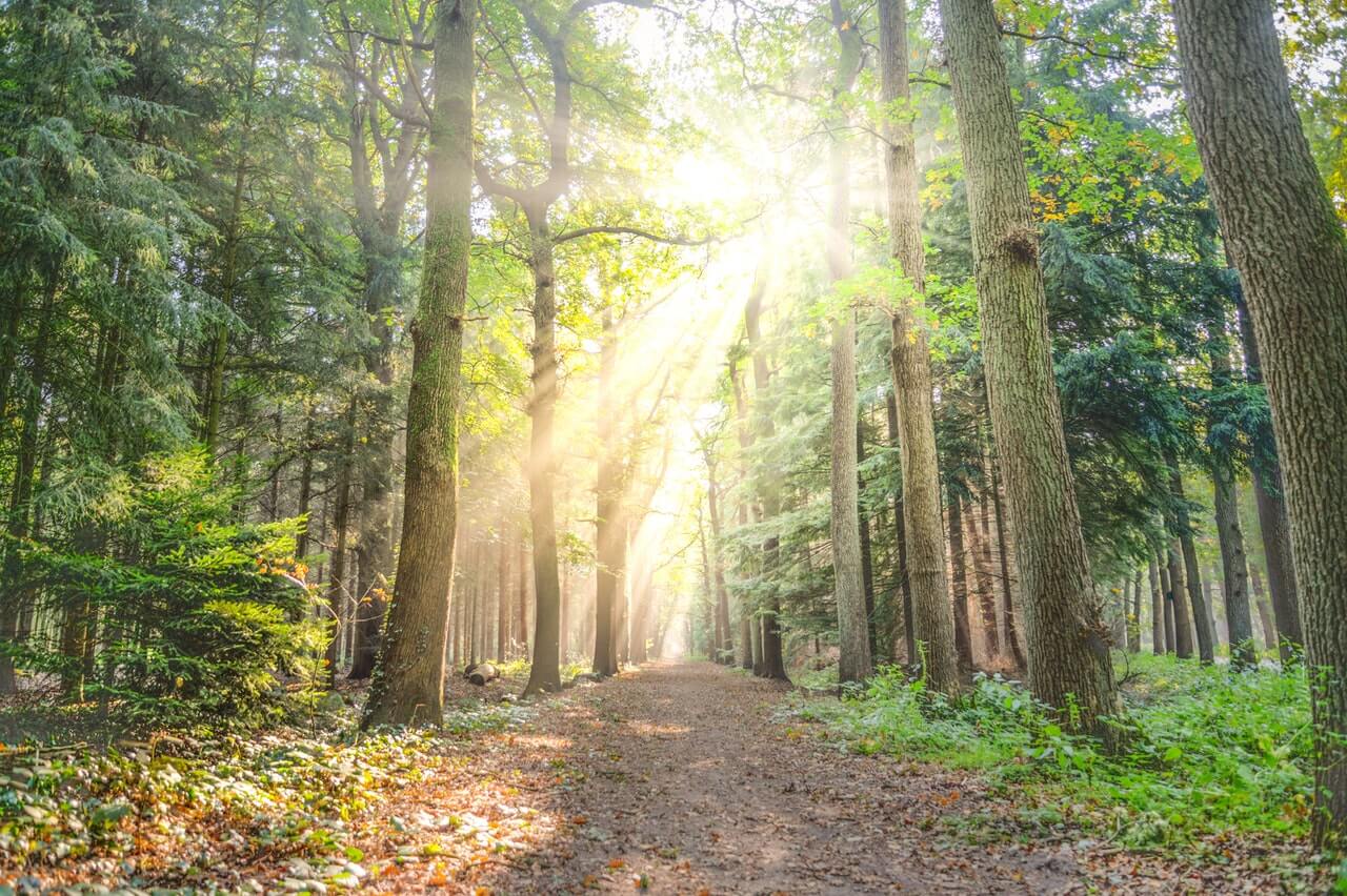
The Forests of the New River Gorge
The mixed mesophytic forest of the New River Gorge is one of the most biodiverse in the world. There are two big reasons why.
First, the unusual north-south flow of the river creates a lone pass through the mountains. Plants and animals that would have a hard time moving over the mountains can migrate by water or land through the New River corridor. In fact, the corridor allowed northern species to escape the glaciers of the ice age by moving south. It may also allow southern species to escape to the north as the earth heats up.
Second, there is typically a 1,000 feet difference in elevation between the river and the top of the plateau. Temperature-wise 1,000 feet in elevation is equivalent to 300 miles of latitude. This means that the rim of the Gorge has a climate that is more like northern Pennsylvania. Stand on the rim of the Gorge in April and you can see this phenomenon – the forest around you will still be leafless while the riverbank below is in full bloom.
Within the park, you can find thousands of different plant and fungi species, 65 species of mammals (from black bears to chipmunks), hundreds of native and migratory birds, amphibians, reptiles, aquatic animals, and fish. New River Gorge is thought to be the second most bio-diverse national park.
It was the abundance of life that resulted from these conditions that drew American Indians to this area to live and hunt 10,000 years ago. Ancestors of the people we know as the Cherokee and Shawnee lived off the land until the mid-1600s when the Europeans arrived.
When you visit the New River Gorge forest, stop and sit quietly for a few minutes. You will get a greater sense the life all around you.
Our hiking recommendation for best experiencing the forest is the Burnwood Trail. This 1.2-mile (roundtrip) moderate trail goes through one of only two designated old-growth forests in New River Gorge National Park.
Reference and Additional Resource
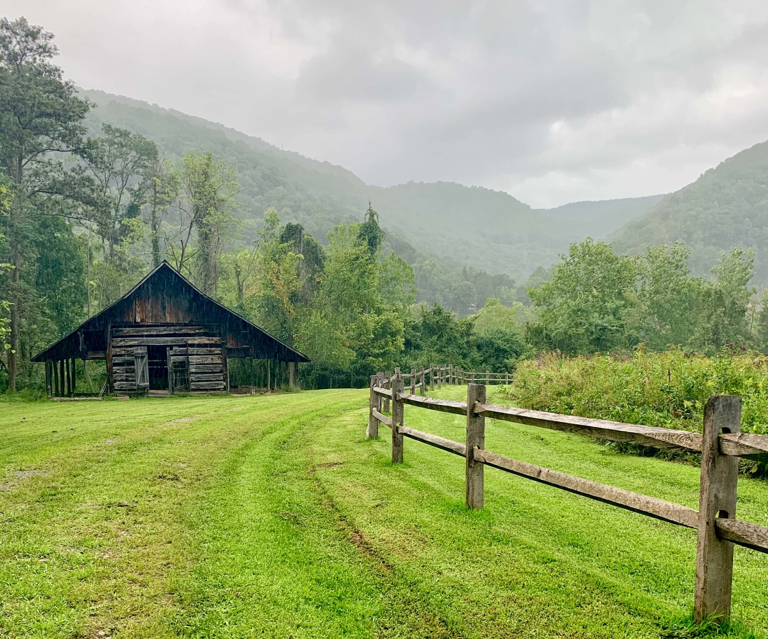
Farming the New River Lowlands
In the southern part of the New River Gorge, near Hinton, WV, the river, mountains, and forest are quite different than in the deepest areas near Fayetteville. Instead of steep cliffs and a narrow river, you’ll find flat bottomland surrounding a wide river. These bottomlands allowed for easier farming, hunting, and transportation.
But make no mistake, even in the southern section living in the New River Gorge was never easy. During the colonization of the United States, most pioneers in search of flat suitable farmland passed through West Virginia, heading west. But some hardy souls stayed and established subsistence farms, growing just enough to meet the needs of their families, unable to grow cash crops.
Most folks don’t know it, but in the 1980s/90s the National Park Service acquired two old subsistence farms you can explore: Richmond-Hamilton Farm and Trump-Lilly Farm.
Our hiking recommendation for best experiencing the southern lowlands is the Big Branch Trail. This 2-mile strenuous loop trail offers ruins of an old hillside farmstead near a mountain stream with great views of Brooks Falls and the southern lowlands below.
Reference and Additional Resource
Coal Mining in the New River Gorge
Around the same time the Trump Lilly Farm was getting established in the southern section of the New River Gorge, coal mining was starting in the northern section.
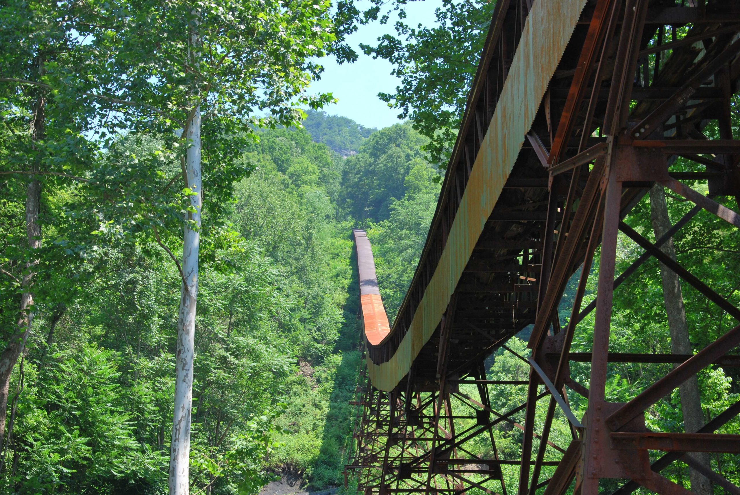
In 1870 an English-born miner named John Nuttall started buying land in the New River Gorge with the intention of coal mining. When the Chesapeake & Ohio Railroad completed its track through the Gorge in 1873, the coal mine and community of Nuttallburg was established.
In Nuttallburg and throughout the New River Gorge, 1-4 feet tall coal seams were found hundreds of feet above the river on the mountainside. The seams were accessed through drift mines which have entrances that are the same level as the coal seam, and tunnel into the mountain horizontally.
A diverse workforce of many races and nationalities worked together in the Nuttallburg mine, but African Americans, who according to the 1900 US census made up 55% of the miners living in New River Gorge mining towns, were segregated above ground and forced to live in different places.
During the 1950s life started to change in coal country. Mechanization increased and miners started losing their jobs. Ultimately, production at Nuttallburg ended in 1958. The Nuttall family transferred ownership of the land to the National Park Service in 1998, and now it’s one of the most intact examples of an early coal mining complex in the United States.
Our hiking recommendation for best experiencing the rich coal mining history is the Nuttallburg Trail System. These seven trails with interpretive signage ranging from easy to strenuous offer exploration of an old coal mining complex (headhouse, conveyor, rail trail, tipple, and lost community homesites).
Reference and Additional Resource
The New River Gorge Bridge
Prior to the 1970s, getting from one side of the New River to the other involved driving down a steep, narrow road to the bottom of the gorge, crossing a small bridge, and traveling back up the other side. You can still drive Fayette Station Road today and we highly recommend the adventure!
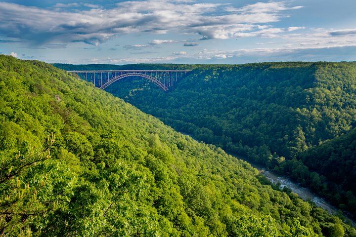
But in 1977, what once took 40 minutes began to take less than one minute! The construction of the New River Gorge Bridge that started in 1974 was complete.
The engineers and ironworks that constructed the bridge faced major obstacles because of the enormous size of the bridge and its remote location. Even getting the heavy steel beams (too heavy for trucks) to the site was a challenge that required the construction of a cable-way system from the trains to the bridge.
The New River Gorge Bridge is 3,030 feet long and the arch measures 1,700 feet. At the time of its construction, it was the longest steel arch bridge in the world and remains the longest single-span bridge in the Western Hemisphere. It sits 876 feet above the New River, making it the third-highest bridge in the United States.
To celebrate this engineering marvel, Bridge Day is held on the third Saturday of every October. This event features food and fun ON the bridge, and hundreds of skilled BASE jumpers hopping over the side.
Our hiking recommendation for best experiencing the New River Gorge Bridge is the Long Point Trail. This 1.6-mile (one-way) easy trail offers the best view of the New River Gorge Bridge. It’s a very popular, so consider visiting on weekdays.
Reference and Additional Resource
Preserving the Natural & Cultural History of the New River Gorge National River
One year after the New River Gorge Bridge was completed, in 1978, the New River Gorge National River was established by the National Park Service. Legislation passed by Congress in December 2020 designated the New River Gorge the 63rd national park in the United States! It is now known as the New River Gorge National Park and Preserve,
In the New River Gorge, the National Park Service has done a great job achieving its often-misunderstood mission which is to preserve the natural AND cultural resources of our country for the enjoyment, education, and inspiration of this and future generations.
This is a place of amazing beauty with a rich supply of natural resources and a deep cultural history. Everything from colliding continents to extractive industry has shaped the New River Gorge into what we experience today. But don’t take our word for it, step onto a New River Gorge hiking trail and see for yourself.
Who are we? Amy & Shawn, New River Gorge hikers, master naturalists, and owners of Lafayette Flats Boutique Vacation Rentals in Fayetteville, WV – the heart of the New River Gorge National Park and Preserve. If you enjoyed this post you might also like:
Choose Your Own Adventure in the New River Gorge
Overlooks In and Around the New River Gorge
New River Gorge Explorer: A 7-Day Itinerary